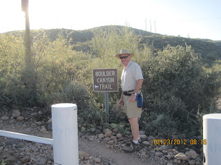
At 8:15, 7 of us set out on the 7 mile (one way) trail - we were not planning on doing the whole trail, just as far as we want to go.
It is an invigorating 2 hour jaunt to the first vista, steep on the way up and very scenic - the scenery is different around every corner!
Below us is Canyon Lake and a large Marina, which is where we started
. There are boat tours on the Dolly Steamship that go out of the Marina.
Diane seems to be asking "Where are we" as she looks at the trail map!
By 11:15 we were back at the trailhead, ready to continue east on Hwy 88 to Tortilla Flat - a famous place to eat out in the middle of nowhere - and it was packed!
There are saddles to sit on at the bar and dollar bills all over the walls. Prior to 1906, this location was a welcome stop for travellers on the Yavapi Trail which connected the Tonto basin with the Salt River Valley. In 1906, the trail, now known as the Apache Trail, was completed as a freight road for the construction of the Roosevelt dam. Tortilla Flat became an important water & supply stop on this road. The Apache Trail is now Arizona State Route 88, but Tortilla Flat remains a welcome stop.

The other hikers returned home, but Marcel, Diane & I continued east on Hwy 88 to the dam. It was about 30 miles on a dirt, washboard road, but by 3:00 we reached the dam and pavement! Completed in 1911, at a cost of $10 million, it was the largest masonry dam in the world for its time with a height of 280 feet (84 m) and a length of 723 feet (216 m).
From there, it was highway all the way back to Mike & Diane's.


No comments:
Post a Comment