The final leg of the journey.....
We didn't get on the road until 11:00 due to much chatting!
Just before 2:00, we stopped at Espanola for lunch at Wendys/Tim Hortons. The place was packed, so we left & carried on.
Stopped in Sturgeon Falls at a Chip stand and had Poutine for Thanksgiving dinner - Awesome!
Arrived home at 4:45pm. Seemed strange to come home without the trailer.
Now to unload, unpack and wait patiently for January........
Thursday, October 13, 2011
Day 55, Savage to Sault Ste Marie, Ontario
We were on the road at 6:45am, in the dark. Crossed Wisconsin, then Michigan. Lost 1 hour due to the time change from Central to Eastern time zone.
Amazingly, there was NO ONE at customs in the Sault! We were all alone driving over the bridge. No problem or delay at customs, although the agent was confused by the fact that we had been RVing for 2 months but did not have an RV! Then off to find our friends, Mike & Diane, where we enjoyed a great supper of turkey and all the trimmings. Today was a 1032km drive!
 Mike has the most awesome garage! It houses his 40 foot RV and the truck. Has a 14 foot high door and must be 60 feet deep!
Had a great visit. They are leaving for Arizona on Wednesday and we plan to meet up in January.
Amazingly, there was NO ONE at customs in the Sault! We were all alone driving over the bridge. No problem or delay at customs, although the agent was confused by the fact that we had been RVing for 2 months but did not have an RV! Then off to find our friends, Mike & Diane, where we enjoyed a great supper of turkey and all the trimmings. Today was a 1032km drive!

Had a great visit. They are leaving for Arizona on Wednesday and we plan to meet up in January.
Days 51 to 54, Savage, Minnesota
Spent a wonderful 4 days relaxing and visiting 3 great-nephews and a great-neice (I think that is how the relationship works???)

We meet Waylon for the first time - he seems happy to see us! He is just recovering from bilateral ear infections that were resistant to the first 2 antibiotics that were given.

As you can see, the weather was gorgeous!


Marcel was allowed to use the sledgehammer, but not the axe!


Wednesday, October 5, 2011
Day 50, October 4, Des Moines to Savage, Minnesota
The adventure continues!
Sunny and 15C this morning as we drove past field after field of dry corn that stretch as far as the eye can see. Some has been harvested, but the majority is still waiting to be cut.
Passed 3 huge wind farms along the way, There must have been at least 100 wind turbines in each one.
At 10:00, we made a fuel stop at a BP station just at the Iowa/Minnesota border. NEVER AGAIN!
Drove up to the green handled filler & started pumping. Unfortunately, after pumping 9 gallons, Marcel noticed it was GAS, not diesel. At every station we have been to, the diesel pump is green - not at BP - their diesel has a yellow handle! The station called a local garage and the tow truck was there in about 5 minutes.

Hauled the truck to the garage, pumped out the fuel tank, put 5 gallons of diesel in and brought the truck back, all within an hour, and we were back on the road.
Apparently, this has happened several times before, as the girl at the station knew just who to call! No more BP stations for us! At least the weather was very pleasant, sunny & 26C.
We finally arrived at my brother's in Savage and will spend a few days visiting family.
Day 49, October 3, Oklahoma City to Des Moines, Iowa
Early start today. By 7:00 we were packed up, fuelled up, said our last goodbyes and webt our separate ways. It was still dark!
By 8:00, the sun was up and we had a clear blue sky. The highway was long, straight and boring! After entering Kansas, the I-35 became the Kansas Turnpike (toll road). 2 hours later, we exited the Turnpike and continued on I-35. Surprisingly, the toll was only $6.00.
We have descended a long way, now at 950 ft elevation and crossing mile after mile of flat farmland.
After passing through Kansas City, we entered Missouri. Leaves are starting to turn. Continued on into Iowa and stopped for the night in north-east Des Moines. Another long day - 900km.
Sunday, October 2, 2011
Day 48, October 2, Moriarty to Oklahoma City
Woke up to a chilly morning, 8C at 6:00. However the skies were clear, so it would be sunny!
Packed up & on the road at 8:00. Elevation 6300 ft.
By 9:00, we were at 5,000ft and it had warmed to 21C.
At 10:55, we entered Texas and had yet another time change, losing an hour (now it is 11:55). Temperature is up to 29C.
At 3:17, we entered Oklahoma and shortly after, stopped at the Travel Information center to pick up maps and hotel coupons. Temp was up to 31C.
Arrived at Meridian Inn Motel at 5:37, after a long day, (812KM). After a Happy Hour, went across the street to a buffet for supper. Then it was off to bed for an early night!
Tomorrow, we go our separate ways, Ken & Lynda will take Hwy 44 towards St. Louis, while we will be going north on Hwy 35 to Minnesota.
Once again, it has been a blast!
Saturday, October 1, 2011
Day 47, October 1, Cottonwood to Albuquerque
This morning we were all up early (before 6am), in anticipation of preparing to leave our "babies" in a foreign location. There was last minute laundry to be done, as well as winterizing the rigs. We were finally ready to leave at 10:25.

Drove 686 KM today to get just east of Albuquerque in Moriarty, where we booked in to a Super 8 Motel with inflated prices due to the Balloon Fiesta!
It was strange to pull in and not have anything to do, like hook up the power & water, level the unit, open the slides.......
The weather was great the whole way, about 27C
Friday, September 30, 2011
Day 46, September 30, Packing up......
Well, it had to come to an end. This morning we drove about 60 miles south to a gorgeous RV Resort where we will stay tonight then place the units in the storage area and hit the road!
No pics from today as it was a "work" day, cleaning, deciding what to take, what to leave, and packing. Beautiful hot, sunny day today. Not looking forward to having to get back into long pants!
Will update when we have Wi-Fi at the hotel/motel.
It's been an awesome trip, thanks in no small part due to Lynda's extensive research & plannng! I don't think we missed much.
 An addendum to this blog - after posting, we were enjoying Happy Hour when the clouds moved in and we experienced a hailstorm which lasted about 1/2 hour. The hail was about 1/4-inch, but hurt when we ran for cover!
Tomorrow, final laundry and packing....,
No pics from today as it was a "work" day, cleaning, deciding what to take, what to leave, and packing. Beautiful hot, sunny day today. Not looking forward to having to get back into long pants!
Will update when we have Wi-Fi at the hotel/motel.
It's been an awesome trip, thanks in no small part due to Lynda's extensive research & plannng! I don't think we missed much.

Tomorrow, final laundry and packing....,
Day 45, Exploring Jerome
Drove down to Verde Valley (Cottonwood) to check out a storage facility/ campground which is about 50 miles south of Flagstaff. It is a 300-acre oasis in the high desert where the climate is moderate year-round. After touring the property, we decided to move there Friday morning, pack up, winterize, park the rigs in the storage area, then start eastward Saturday morning.
 Following that decision, we drove to Jerome, Arizona's largest ghost town. It was an interesting drive up the mountain with switchbacks & steep climbs, finally reaching the town at 5,280ft.
 The town was built on Cleopatra Hill above a vast deposit of copper. Mining operations started in 1883 and the tent city grew rapidly to a prosperous mining town. Dependent on the ups & downs of copper prices, labour unrest,depressions and wars, Jerome's mines finally closed in 1953. It went from a boom town of 15,000 to a ghost town.
 It has been revitalized as an art colony, and became a National Historic Landmark in 1967.


Thursday, September 29, 2011
Day 44, September 28, Touring Sedona
Marcel & Ken went off to check out storage facilities in the area. Apparently Flagstaff gets a lot of snow, so we would prefer to move further south into the valley.
Went for a drive to Sedona, which we had heard was an awesome place. Drove Hwy 89A, which is a beautiful, winding drive with many 6% down grades. Flagstaff is at 7000ft. and Sedona is 4500 ft. It was an interesting drive!
 Sedona is very commercialized, full of jewellery & T-shirt shops! We explored the town for 2 hours and it was HOT!
 It is surrounded by fascinating rock formations.
 They really like their roundabouts here! There are several as you drive through town.
 The main street is very pretty with flowers & greenery (which must be kept watered as there is very little precipitation).
 Next we drove up to the Sedona Airport, which is America's most scenic airport and sits on a mesa at 4827 ft. From the outlook, the overview of Sedona was awesome!
Then it was on to Red Rock country. Stopping at a viewpoint, we had a superb view of some interesting rock formations, the second pic is a formation called "the Courthouse". I didn't catch the name of the first pic.


Went for a drive to Sedona, which we had heard was an awesome place. Drove Hwy 89A, which is a beautiful, winding drive with many 6% down grades. Flagstaff is at 7000ft. and Sedona is 4500 ft. It was an interesting drive!


Then it was on to Red Rock country. Stopping at a viewpoint, we had a superb view of some interesting rock formations, the second pic is a formation called "the Courthouse". I didn't catch the name of the first pic.


Wednesday, September 28, 2011
Day 43, September 27, Page to Flagstaff, Arizona
Great Wi-Fi at the campground yesterday, but the Blog didn't do what I wanted it to do and caused much frustration. Will see what happens today!
By 10:00, we were packed up & heading south on Hwy 89 to Flagstaff.

Interesting landscape as we emerge from a canyon.
Once out in the open, it was a 6% downgrade for the next 2 miles. We passed many roadside stands selling Navajo items (jewellery and pottery) most of them were empty - off season?
 The everchanging landscape - desolate with very little growing on the rocky terrain. Has warmed up to 28C.
 Now we are getting into the mountains & trees at 6400 ft. elevation. A sight for sore eyes after seeing so much desert, rocky and barren land.
 After setting up at the campground just north of Flagstaff, we went to Sunset Crater Volcano National Monument. Sunset Crater is a 1,000 ft high cinder cone formed by a volcanic eruption about 800 years ago. We took a 1 mile walking trail which explained the history of the area. The trail took us past the lava flow, which was quite amazing.
Hundreds of volcanic eruptions gave life to this region's present landscape. All the hills and mountains around are volcanoes. They are part of the 2,200 square mile landscape of lava flows, cinder cones & other volcanic wonders know as the San Francisco Volcanic Field.
We continued on the park's loop road to the Wupatki National Monument, which consists of several ancient dwellings of Puebloan peoples.
 We stopped to tour one ruin called Wukoki, which resembles an old castle. Meticulous corners and lines of masonry rise up from the bedrock to a 3-storey-height.
 Despite exposure to the elements for 800 years, it still stands as a tribute to Puebloan ancestors who paused to farm here during the 1100's.
End of the day!
By 10:00, we were packed up & heading south on Hwy 89 to Flagstaff.

Interesting landscape as we emerge from a canyon.
Once out in the open, it was a 6% downgrade for the next 2 miles. We passed many roadside stands selling Navajo items (jewellery and pottery) most of them were empty - off season?


Hundreds of volcanic eruptions gave life to this region's present landscape. All the hills and mountains around are volcanoes. They are part of the 2,200 square mile landscape of lava flows, cinder cones & other volcanic wonders know as the San Francisco Volcanic Field.
We continued on the park's loop road to the Wupatki National Monument, which consists of several ancient dwellings of Puebloan peoples.


End of the day!
Tuesday, September 27, 2011
Day 42, September 26, Touring Powell Lake Area

It gets dark by 7:00pm and is light by 6:00am, so this morning I went for a hike up the hill behind the campground. From the top was a great view of the campground.
After breakfast, we all went for a drive. Found the trailhead for the Horseshoe Bend Trail, which is a 1.5 mile round trip.


It started as a sandy, uphill walk, then at the top of the hill it became bumpier. It alternates between whitish gravel, more sand, ad some solid, sloping rocks, the Navajo Sandstone.

.Upon reaching the end of the trail, the view of Horseshoe Bend from the rim of the canyon is eztraordinary. You need a wide-angle lens to capture the entire scene! The Colorado River created a 270 degree horseshoe-shaped bend in the canyon 1000 feet down. The river flows from the right, around the bend, then exits to the left. We spent some time soaking up the awesome views.


Next, we stopped at a "scenic view", which involved another short hike down to a fantastic viewpoint of dam. 


Then it was off to Wahweap, which consists of several large marinas, mainly mooring huge houseboats.


Our last stop was at "Lone Rock", where there was a lovely beach and several RV's camped along the shore. Lone Rock is a huge square rock that sits in the middle of the lake.

Monday, September 26, 2011
Day 41, September 25, Hurricane, Utah to Page, Arizona
At 9:45, we were packed up and on the road, climbing out of the valley which houses Hurricane. The skies are clear with a temperature of 23C.
Half an hour later, we entered Arizona and had yet another time change. Arizona does not observe daylight savings time and is one hour earlier than Utah in Spring & Summer.
Passed by Colorado City, a town of many large homes where polygamy is practiced. What do these men do for a living in order to support multiple wives and all their children???
 Turned off Hwy 389 at Pipe Spring National Monument, which is an oasis in a seemingly uninhabitable region of high desert. The spring was a source of survival where the Mormons built a fort to protect them from indian attacks. They also ran a very sucessful ranch there. We had a Ranger-led tour of the fort, named Windsor Castle and the grounds.
The highway curved back north into Utah, through Kanab. At Big Water we saw our first sign of water! Shortly afterward we re-entered Arizona. There was a beautiful view to the left, but no where to stop for a photo! Arrived at Page-Lake Powell Campground & got set up.


Half an hour later, we entered Arizona and had yet another time change. Arizona does not observe daylight savings time and is one hour earlier than Utah in Spring & Summer.
Passed by Colorado City, a town of many large homes where polygamy is practiced. What do these men do for a living in order to support multiple wives and all their children???

The highway curved back north into Utah, through Kanab. At Big Water we saw our first sign of water! Shortly afterward we re-entered Arizona. There was a beautiful view to the left, but no where to stop for a photo! Arrived at Page-Lake Powell Campground & got set up.
Off to the Carl Hayden Visitor Centre at the Glen Canyon Dam.
The dam was constructed between 1956 & 1966 in a virtually inaccessible area on the Colorado River, 8 miles below the Utah-Arizona border. It is the second-tallest concrete arch dam in the U.S. (Hoover Dam is 17 feet higher). The crest of the dam spans 1,560 ft and rises 710 feet above the bedrock.


At 700 feet above the Colorado River, the Glen Canyon Bridge is the second-highest steel-arch bridge in the world and was opened in February, 1959. Prior to the construction of the bridge, the road distance from one side of the river to the other was 197 miles!

Lake Powell was created when the dam was built. It is 186 miles long and backs up into more than 96 major side canyons. Its 1960 miles of shoreline are longer than the length of the whole western coast of the continental US. It is the second-largest man-made lake in the US, after Lake Mead.
Sunday, September 25, 2011
Day 40, September 24, Rest Day
Decided to stay put and clean the rigs.
In the afternoon, Marcel & I went for a drive to Wal-Mart, which turned out to be a scenic drive from hell. The woman at the campground gave me directions for a 20-mile scenic drive to Kolob Canyon, but being directionally challenged, I instructed the driver to turn one street earlier than we should have. It started out at 2:30, to be a nice drive at 3200 ft., but soon deteriorated to a narrow, rocky trail, going up & up on Mesa Road.

 15 minutes later, we were at just over 5000 ft., then at 3:06 w were at 5600 ft. The views were awesome, even if we were on the wrong road (which we didn't know yet)
 By 3:30 we were at 5800 ft., among flat plains at the top of the mesa, where there were a couple of ranches and cattle grazing. One wonders if you would need a helicopter to access this place!
 Yet another winding road, down this time. It seem that at least once on every trip we end up on an off-roading adventure!
In the afternoon, Marcel & I went for a drive to Wal-Mart, which turned out to be a scenic drive from hell. The woman at the campground gave me directions for a 20-mile scenic drive to Kolob Canyon, but being directionally challenged, I instructed the driver to turn one street earlier than we should have. It started out at 2:30, to be a nice drive at 3200 ft., but soon deteriorated to a narrow, rocky trail, going up & up on Mesa Road.

 15 minutes later, we were at just over 5000 ft., then at 3:06 w were at 5600 ft. The views were awesome, even if we were on the wrong road (which we didn't know yet)
 By 3:30 we were at 5800 ft., among flat plains at the top of the mesa, where there were a couple of ranches and cattle grazing. One wonders if you would need a helicopter to access this place!
By 4:00, we passed a sign the read "Entering Zion National Park."! A short while later, we passed a sign at a fork in the road, (when I looked back) for Kolob Canyon. Apparently, we were on Smith Mesa. Oops.
 Yet another winding road, down this time. It seem that at least once on every trip we end up on an off-roading adventure!
This pic shows where we were - at the top of the mesa!

The truck sure needed a wash after this trip as it was covered in red dust!
Saturday, September 24, 2011
Day 39, September 23, Zion to Hurricane, Utah
Yet another beautiful, sunny day - gets a bit boring after a while! The campground is full for tonight, so we will be moving on.....short drive to Hurricane, then we can visit St. George from there. St. George was settled during the Civil War by Mormons sent by Brigham Young to grow cotton.
After getting set up at Willowind Campground, went to the Visitor Centre in St. George where we picked up a "Stroll Through History" brochure which is a walking tour of Historic Downtown St. George. The Visitor Centre is located in the old Courthouse, built from 1866 - 1876. It has many interestind and unique architectural features, including 18-inch thick interior doors, old chandeliers and a cupola.
Next stop was the winter home of Brigham Young, which was built around 1873, has been restored and contains 19th century furnishings. The fascinating part of the home was the fact that all the woodwork - floors, windowsills and furniture - is made of pine painted to simulate the grain of hardwoods. It was too costly to import hardwood. Sorry, no photos - was too interested in listening to the guide!
 We walked on the the Mormon Tabernacle, which took 13 years to build, completed in 1863. It is built on 3-foot thick basement walls. The 52-foot trusses were cut & hand-hewn in Pine Valley then hauled into towm on wagons. The 140-foot steeple serves as a town landmark. Our guided tour offered insight into the history of the church as well as the people who contributed to its development.
It is at least 90F today and was 99F yesterday!
 The spectacular twin circular staircases were meticulously hand-carved, complete with balustrades and railing.
 Then it was on to the St. George Mormon Temple, which is a very imposing structure, built 1869 -1877, and was the first Mormon Temple built in Utah. Of course, we are not allowed inside, but went to the Visitor Centre. There were interesting displays and an interactive video shown which demonstrated Mormon beliefs.
That pretty much wraps up our day.
After getting set up at Willowind Campground, went to the Visitor Centre in St. George where we picked up a "Stroll Through History" brochure which is a walking tour of Historic Downtown St. George. The Visitor Centre is located in the old Courthouse, built from 1866 - 1876. It has many interestind and unique architectural features, including 18-inch thick interior doors, old chandeliers and a cupola.
Next stop was the winter home of Brigham Young, which was built around 1873, has been restored and contains 19th century furnishings. The fascinating part of the home was the fact that all the woodwork - floors, windowsills and furniture - is made of pine painted to simulate the grain of hardwoods. It was too costly to import hardwood. Sorry, no photos - was too interested in listening to the guide!

It is at least 90F today and was 99F yesterday!


That pretty much wraps up our day.
Friday, September 23, 2011
Day 38, September 22, Zion National Park, Utah
What a difference a day makes! We had a low of 18C last night. At 7:45 A.M. it is still dark down in the canyon.
 Another view of our backyard. It is amazing to get up in the morning to this scene. There are rare places on earth that neither words, nor pictures can capture. When you enter Zion you experience a feeling that won't quite fit inside your camera. However, I'll try to show some of the beauty of this country.
 We hopped on the shuttle & went into the park, stopping at the "Court of the Patriarchs", which are 3 towering figures of the Old Testament.In 1916, a Methodist minister gave the religious names, Abraham, Isaac and Jacob to the peaks.
 The next stop was Zion Lodge, which is the trailhead for the Emerald Pools trail.We took the 0.6 mile 'Lower Pools' trail which led us to a beautiful oasis with panoramic views up & down the canyon. Year round seeps & springs continually recharge the pools.
 We continued on around the 'Kayenta' trail, which was another 1.8 miles up, down, around and through, ending at The Grotto shuttle stop.
 Got on the shuttle to the next stop, the Weeping Rocks. This involved a short but steep 1/2 mile trail. Wonderful scenery. The trail ends at an alcove with dripping springs and hanging gardens..
 Then we decided to take the "Hidden Canyon" trail, which we were told was well worth it. Thought it was a 1 mile trail which ascends 850 feet, but after climbing for 1/2 hour, we were told that we weren't halfway. Turned back as we were going to drive Hwy 9 throug the tunnel this afternoon. Beautiful blue skies are all around us.
We had lunch at the Zion Canyon Lodge (overpriced, of course!) then stopped at the Human History Museum to watch the 22 minute movie about the park. Shuttled back to the campground, picked up the car to drive the Zion - Mount Carmel Highway and go through the 1.1 mile tunnel (which is an engineering marvel).
 The highway consists of several switchbacks. Sorry, the pic of the GPS screen isn't as good as I hoped. It was a pretty curvy highway!
 After driving through the tunnel and continuing on the highway, we turned around and came back to the parking lot by the tunnel.
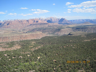
 There is a 2 mile Canyon Overlook trail which was a rocky and uneven trail ending at an awesome viewpoint of Pine Creek Canyon & lower Zion Canyon. This shows part of the road that we drove......


We had lunch at the Zion Canyon Lodge (overpriced, of course!) then stopped at the Human History Museum to watch the 22 minute movie about the park. Shuttled back to the campground, picked up the car to drive the Zion - Mount Carmel Highway and go through the 1.1 mile tunnel (which is an engineering marvel).


Subscribe to:
Posts (Atom)