Monday, October 8, 2012

Wednesday, Oct 3, Moving on to Massachusetts

Packed up under cloudy skies & occasional drizzle.
It rained off & on all the way to the Minuteman Campground, where we set up in the rain.

At 2:30, we were off to Boston. The campground advised us that you do not drive into Boston, as parking is expensive & not readily available. The best way to go is on the Massachusetts Bay Transportation Authority (MBTA), which operates the city's buses, trolleys, boats and subway - all of them an efficient alternative to driving.
Known as the "T", Boston's rapid transit system is the nation's oldest, the first stretch opened in 1897. The subway system is very extensive, with four main lines, the red, blue green and orange which radiate from the central downtown locations. We each purchased a 7-day pass, which allowed unlimited travel for the duration of our Boston visit.
We took the subway in from the Riverside station, which was a 45 minute ride. Walked around trying to get our bearings and came across a crowd of people with cameras and several Boston Police outside the Mandarin Oriental Hotel. Wondered what was going on as we made our way to "Legal Seafood" for dinner.
Had a great dinner, Terry enjoyed a lobster,


while Marcel had the "Fisherman's Platter".


On the way back to the subway, we stopped at the Hotel & asked  the doorman who of importance was there. Apparently Chevy Chase hosted a private party for several comedians, including Mr. Bean,  Bill Murray and others. 

Thursday, October 4, Touring Boston

Drove in to the Riverside subway & took the "T" in to City Place to pick up our 2-day Beantown Trolley Pass. Once onboard, you can tour at your own pace, with the freedom to disembark and re-board at your leisure at any of the16 stops. Or you can sit back and relax during the 110 minute tour.

We went by the original "Cheers" Bar, where everybody knows your name,


Also on the route was the huge Boston Public Library, Boston Symphony Hall, The Old North Church (built in 1723 and is the oldest surviving church building in Boston, Fenway Park, the site of the Boston Tea Party, and the Mapparium among many other points of interest.


The Mapparium is a three-story tall glass globe of over 400 panels of stained glass that is viewed from a 30-foot-long (9.1 m) bridge through its interior. It is a unique exhibit at The Mary Baker Eddt Library. It was fascinating to stand inside a globe instead of looking at it from the outside!
Built in 1935 and based upon Rand McNally political maps published the previous year, the Mapparium shows the political world as it was at that time, including such long-disused labels as Italian East Africa and Siam, as well as more-recently defunct political entities such as the Soviet Union. In 1939, 1958, and 1966 the Church considered updating the map, but rejected it on the basis of cost and the special interest it holds as an historical artifact.

At 1:30, we boarded the Boston Harbour Cruise, which was a fully narrated 45 minute tour of Boston's inner harbour. It took us to the Charlestown Navy Yard where the USS Constitution is moored. We disembarked and toured the world's oldest commissioned warship still afloat. The 44 gun frigate was costructed of seasoned live & white oak and was launched in 1797. She has the nickname "Old Ironsides" because during a battle in the War of 1812, a cannonball fired from a Britisg frigate just bounce off her hull. A sailor on board exclaimed "Her sides are made of iron!" and the nickname has stuck ever since.
 
Following the tour, we boarded the next Harbour Cruise boat for the trip back to the harbour and the Trolley. Finished the Trolley tour, then on to the subway and back to the campground aftera busy day!

Tuesday, Oct 2, Mount Washington Auto Road

At 9:00, we packed up a picnic lunch & headed off to climb Mount Washington (by truck, not on foot!). At 6,288 ft  it is the Northeast's highest peak. The description of the road is as follows: The scenic trip requires 30 to 45 minutes each way; frequent turnouts provide views. Low gear should be used both ways. Because of steep grades and sharp curves, driving instructions are available at the toll house and should be heeded. Sounds like a fun trip!
Along Hwy 3, there were low clouds in the mountains. There were some beautiful colours but they don't really show to their advantage in pics.


At 10:35, we arrived at the toll house nd were met with this warning. We carried on, regardless!
At this point, we were at 1,676 ft., the temperature was 15C and the average grade for the road is 12%.


At 11:23 we arrived at 6,205 ft and parked. The temperature is now 9C and it is windy. We walked up to the observation deck and the sign that proved that we made it!
It is always very windy up there, in fact, the weather here rivals that of Antarctica; the average annual temperature is below freezing. Fifteen feet of snow is the winter norm, and the summer temp rarely exceeds 72F. The highest wind velocity ever recorded - 231mph - occurred in April 1934.


After wandering around the observation deck and the Mt Washington Observatory Museum, we returned to the truck to start down.
This is the observation deck, taken thru the back window of the truck.

By 1:15, we were back to the toll house, went across the street to Glen House and enjoyed our picnic lunch. It is now 21C, much warmer than at the summit!


Next stop on the road was the Flume Gorge in Franconia Notch State Park (which we didn't visit yesterday because it was too foggy), and walked the 2 mile path. The Gorge is a chasm extending nearly 800 ft along the flank of Mount Liberty. A mountain stream tumbles in a series of waterfalls and pools between its 60 to 90 foot high granite walls.

Along the path, we came across this 300 ton boulder that was deposited by a glacier.


Next was the picturesque covered bridge over the Pemigewasset River, built in 1886, which makes it one of the oldest in the state. It has been restored several times.


Over time, the rushing waters of the Flume Brook has exposed this large outcropping of rock. Table Rock is a section of Conway Granite that is 500 ft (150M) long and 75 ft (20M) wide.


The walls of Conway granite of the Flume rise perpendicularly to a height of 70 - 90 feet and vary in width from 12 to 20 feet.The Flume was discovered in 1808 by a 93 year old woman when she accidently came upon it while fishing. At that time a huge egg-shaped boulder 10 ft high and 12 ft long, hung suspended between the walls. A heavy rainstorm in 1883 started a landslide that swept the boulder from its place. It has never been found.


The Pool is a deep basin in the Pemigewasset River. It was formed at the end of the Ice Age 14,000 years ago by a silt-laden stream flowing from the glacier. The Pool is 40 feet deep and 150 ft diameter and is surrounded by cliffs 130 ft high.


The Struggle for Survival
This is evidence of how nature must sometimes struggle to survive. This large and very old Yellow Birch sprouted from a seed, perhaps dropped by a bird or carried by the wind and then germinated upon a rock. As the tree grew, its root system reached out to the soil below. This is a common occurrence here in Franconia Notch due to the thin soil, rocky terrain and the poor growing conditions.

Saturday, October 6, 2012

Monday Oct 1, Scenic 100 mile drive

After raining steadily all night, it finally stopped at 7:30 this morning. At 9:00, we set off on the "Scenic Byway" trip, a 100-mile drive. Our first stop was at Franconia Notch State Park, Flume Gorge & Visitors Centre, where we watched a 20 minute video about how the region evolved. There were some lovely colours to see, however, it is hard to capture the true colour with photos!


  Next stop was at the "Basin", a large pothole in the Pemigewasset River, 30 feet in diameter and 15 feet deep, which had its beginnings some 25,000 years ago as the ice age came to a close.
No swimming allowed!


The next stop held an interesting story. It is named Boise Rock, and according to history, Thomas Boise was sledding through the notch in mid-winter, soon after the first road was built. Overtaken by a fierce snowstorm, he was unable to continue. Realizing he must take drastic action to survive, he killed & skinned his horse. Crawling under the overhang of the rock, he wrapped himself in the hide & spent the night. Men sent out the next day to search for him found Tom still alive but encased in the frozen hide that had to be cut away with axes to release him.

Then it was on to check out the Mount Washington Cog Railway. It was a foggy, drizzly day, so we had no intention of taking the train up the mountain, but we did see some trains coming down. There is one steam engine, but the rest are diesel.
There is an interesting museum there, also.


We passed by the Mount Washington Hotel, which opened in 1902, the Flume & Silver Cascades (waterfalls) and the site of the historic Willey Slide, where the Willey family of seven and 2 hired men died in an 1826 landslide.
We made a stop at the "Covered Bridge Gift shop", just to check it out. It was interesting.


We saw a couple of other covered bridges on the route, then reached the Kancamagus Highway, one of the most spectacular sections of the White Mountains Trail, which would complete our trip.
While stopped at Sugar Hill Overlook, and a rainbow appeared! 


The final stop on the route was ar Pemigewasset Overlook, which was a great display of Fall colours. Again, they don't show their true brilliance in photos!


Sunday, September 30, 2012

Sunday, Sept 30, Travel day to Woodstock, New Hampshire

Pulled out of a rain-soaked campground at 9:05, heading back north to Burlington. Trying  not to tip over! Rain was falling lightly.

After turning south-east past Burlington, we stopped at a full service rest area - there was a family set up there with bagels, butter, cream cheese, doughnuts, fruits, muffins,  coffee & much more - all for a donation. They are raising money to help with the costs of their daughter's skating equipment.
The skies appear to be clearing.......

We went through Montpelier, which is the Vermont state capitol and passed by the State Capitol building, complete with the gold-domed roof.


There were  beautiful colours going through Marshfield at 1200 ft elevation. The photo doesn't do it justice. A sunny day would have been nice!


We stopped at the small town of Joe's Pond, where there is a covered footbridge. It started raining while we were there.


We saw some vibrant colours on the hillsides, but it was hard to take a picture when moving at 60 mph!
At 12:47 we entered New Hampshire.
We passed by Cannon Mountain Ski Hill which has an aerial tramway that ascends to the 4100 ft summit (which we couldn't see due to the low clouds!)


Around the corner to the backside of the mountain was sheer rock!


Arrived at the KOA Woodstock under light rain, got set up & went in to town for fuel & groceries.


Saturday, September 29, 2012

Saturday, Sept 29, Touring to Stowe

It is cloudy and 12C this morning as we head off to Stowe. Apparently, the leaves are at their peak there this weekend.
Along the way, we stopped at a Farmers' Market in Shelburne, under drizzly skies.

Next, we came across "Ben & Jerry's" Ice cream factory in Waterbury. www.benjerry.com  Of course, we took the factory tour, but there is no production on weekends and no photography allowed during the tour.
However, it was interesting to hear the story of how Ben & Jerry's came about.


At the end of the tour, we got to sample the newest flavour - Chocolate Nougat Crunch.


On the way out, bought 2 cones, which came to $8.99!!!


Then we continued on to Stowe, with showers off & on. The leaves were beautiful, but the cloudy weather didn't help. Stopped at Stowe Mountain Lodge, which is HUGE!


The next stop was at Mount Mansfield, which is Vermont's highest peak at 4395ft. The gondolas were running, but we felt $25.00 per person was a bit much since 3/4 of the mountain is shrouded in clouds!

We headed back south & stopped at Lake Champlain Chocolates, which was an Outlet store, not a production place. Bought some chocolate anyway!

Drove the scenic route back to the campground and arrived at 4:30, just in time for Happy Hour.
On the move tomorrow.


Friday, Sept 28, Burlington, Vermont

Woke up to a cloudy, damp morning. 9C.
Drove north to Burlington and the skies cleared - for a short while.
We found a place to park near the Church Street Marketplace (similar to Sparks St in Ottawa). As we wandered along the street, we came across this interesting-looking bicycle. The owner was nowhere in sight.


There are many decorated Teddy Bears along the street, sponsored by companies. Remember Toronto's moose?

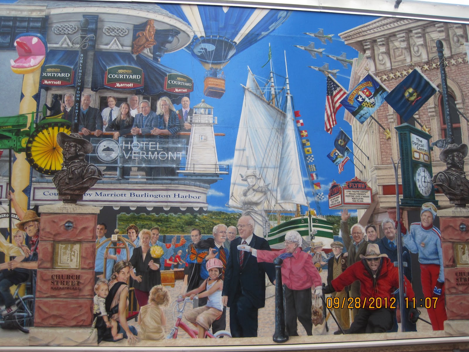
After enjoying a pub lunch at Ri Ra Irish Pub, we came across a side street which had the entire wall covered with beautiful murals depicting a parade.


The next stop was Ethan Allen Park where we walked up a trail amongst towering trees to reach the Ethan Allen Tower, erected in 1905 to honour Vermont's revolutionary war hero.


We climbed the tower which offers good views of Green Mountain, the Adirondacks and Lake Champlain. Unfortunately, the day was cloudy, which limited the visibility. This area is in the "Banana Belt", so the leaves haven't turned much yet.


On the way back to the campground, we stopped at the Vermont Teddy Bear Company, where we took a guided tour. It offered a glimpse of the step-by-step creative process required to hand craft these jointed teddy bears.


A bear is created in 12 minutes, from start to finish, and they produce almost 500,000 bears a year, which are shipped all over the world!


That was enough for one day, as we headed back to the campground.